


US Topo Maps
Описание на US Topo Maps
Лесно за използване приложение за навигация на открито с безплатен достъп до най-добрите налични карти и въздушни изображения за САЩ.
Изберете между 30+ слоя карти (топоси, антени, морски карти, ...), за да планирате перфектното пътуване и
превърнете своя телефон/таблет Andoid в GPS на открито за офлайн пътувания в провинцията.
Добавяйте лесно карти от други източници (GeoPDF, GeoTiff, онлайн картографски услуги като WMS, ...)
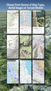
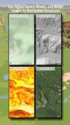
Налични слоеве на базова карта за САЩ:
• USGS National Map Topo
• USGS National Map Imagery Topo
• Национална карта на USGS
• USGS NAIP HiRes изображения
• Традиционни DRG на USGS Topo: Безпроблемно покритие на топографски карти на САЩ в мащаби 1:250 000, 1:100 000, 1:63 000 и 1:24 000/25 000
• Карти на горите FSTopo
• NOAA Nautical RNC карти
• Национални карти на надморската височина (Shillshade, Slope Map, Aspect Map)
Слоеве на основната карта на света:
• OpenStreetMaps (5 различни оформления на карти), също могат да се изтеглят във векторен формат, който спестява място
• Google Maps (сателитни изображения, пътна карта и карта на терена)
• Карти на Bing (сателитни изображения, пътна карта)
• Земята през нощта
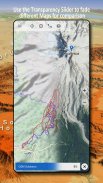
Конфигурирайте слой с базова карта като наслагване и използвайте фейдър за прозрачност, за да сравнявате безпроблемно картите една с друга.
Добавете карти от други източници:
• Импортиране на растерни карти в GeoPDF, GeoTiff, MBTiles или Ozi (Oziexplorer OZF2 & OZF3)
• Добавете услуги за уеб картографиране като WMS или WMTS/Tileserver
• Импортирайте OpenStreetMaps във векторен формат, напр. цели САЩ само за няколко GB
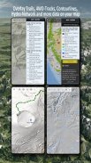
Налични наслагвания на карта на САЩ - добавете допълнителна информация към всяка друга основна карта:
• Публична собственост върху земя (PAD-US 3)
• Национален набор от хидрографски данни
• Карта за използване на моторни превозни средства (USDA)
• Контурни линии на кота
• 4WD пътеки
• Пътеки
• Пътища, железопътни линии, летища
Налични наслагвания по целия свят:
• Хълмово покритие
• 20m контури
• OpenSeaMap
Няма идеална карта. Превключвайте между различните слоеве на картата или използвайте функцията за сравняване на карти, за да намерите най-интересния маршрут. Особено старите традиционни DRG съдържат много малки пътеки или други характеристики, които липсват на съвременните карти.
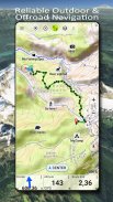
Основни характеристики за навигация на открито:
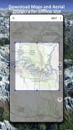
• Изтеглете картографски данни за ОФЛАЙН ИЗПОЛЗВАНЕ
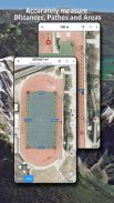
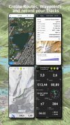
• Измерване на пътеки и площи
• Създаване и редактиране на точки
• GoTo-Waypoint-Navigation
• Създаване и редактиране на маршрути
• Навигация по маршрут (навигация от точка до точка)
• Запис на следа (с профил на скорост, надморска височина и точност)
• Tripmaster с полета за одометър, средна скорост, пеленг, денивелация и др.
• GPX/KML/KMZ импорт/експорт
• Търсене (имена на места, POI, улици)
• Вземете надморска височина и разстояние
• Персонализируеми полета с данни в Map View и Tripmaster (напр. скорост, разстояние, компас, ...)
• Споделяне на точки, следи или маршрути (чрез имейл, Dropbox, WhatsApp, ..)
• Използвайте координати в WGS84, UTM или MGRS/USNG (Военна мрежа/Национална мрежа на САЩ),
• Повторно възпроизвеждане на песен
• и много други ...
Използвайте това приложение за навигация за дейности на открито като туризъм, колоездене, къмпинг, катерене, езда, каране на ски, кану, лов, обиколки с моторни шейни, офроуд обиколки с 4WD или търсене и спасяване (SAR).
Добавете потребителски точки във формат дължина/широчина, UTM или MGRS/USNG с WGS84 данни.
Импортиране/Експортиране/Споделяне на GPS-точки/тракове/маршрути в GPX или Google Earth KML/KMZ формат.
Вижте анимиран дъждовен радар NEXRAD, за да направите точни прогнози кога ще започне/спре да вали
Моля, изпращайте въпроси, коментари и заявки за функции на support@atlogis.com
US Topo Maps - Version 7.7.0
(15-02-2025)US Topo Maps - APK информация
APK версия: 7.7.0Пакет: com.atlogis.northamerica.freeLatest Version of US Topo Maps
Други версии


Apps in the same category


